


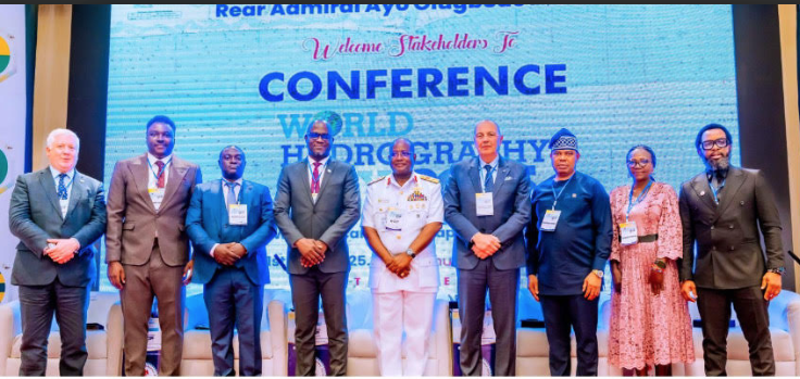
As global efforts intensify to unlock the economic and environmental potential of the oceans, Nigeria is emerging as one of Africa’s most assertive players in the maritime space. Through strategic investments in seabed mapping and digital charting technology, the country is turning previously uncharted waters into instruments of national progress—securing its coastline, safeguarding navigation, and laying the groundwork for a thriving blue economy. This much was made clear at the 2025 World Hydrography Day celebration and West African Hydrographic Summit held in Abuja, recently. Chiemelie Ezeobi writes that by developing the Electronic Navigational Chart (ENC) capabilities and expanding its hydrographic infrastructure, Nigeria is not only enhancing maritime safety but also charting a path toward economic diversification. From renewable energy and food security to maritime trade and job creation, the country is leveraging ocean data to transform its economy and assert leadership in the region’s emerging blue economy
As of mid-2025, 27.3 per cent of the world’s ocean floor has now been mapped to modern standards—an increase of more than 4 million square kilometres in just one year. That’s an area roughly the size of the entire Indian subcontinent.
This milestone, announced shortly after the UN Ocean Conference in Nice and at the halfway point of the UN Ocean Decade, underscores a powerful truth: the ocean floor holds answers to some of the world’s most urgent needs—from tsunami warning systems to offshore renewable energy, cable safety, and biodiversity conservation.
In West Africa, Nigeria is taking the lead, recognising that by investing in seabed mapping and Electronic Navigational Chart (ENC) capabilities, the country is not only improving maritime safety but actively building a blue economy that promises economic diversification, food security, job creation, and energy development.
World Hydrography Day and West African Hydrographic Summit
This was the driving message at the 2025 World Hydrography Day celebration and West African Hydrographic Summit, held in Abuja recently at the Abuja Continental Hotel, where Nigeria announced bold plans to position itself as a regional leader in hydrography and maritime innovation.
From the ice-breaker event at the Abuja Continental Hotel, attended by foreign delegates, partners, Nigerian hydrography icons, industry professionals and maritime stakeholders including Rear Admiral Luigi Sinapi, Director, International Hydrographic Organisation; Mr Jamie McMichael Phillips, Director, GEBCO Seabed 2030 Project; Capt Mostafa Tafrhy, Hydrographer of Morocco; and Dr Kamal-Deen Ali, Director, Ghana Maritime Authority, which ended by celebrating Rear Admiral Osunmakinde, retired Nigerian Navy Hydrographer, on his 80th birthday, the two-day event was carefully curated to lay the groundwork for a thriving blue economy.
Presentations like “Innovations in Hydrographic Technology” by Surv. Paul Adegoke Adeyeye; “Seabed Mapping: Enabling Ocean Action” by Olajide Fagbewesa; and “Mapping the Ocean Floor: The Seabed 2030 Vision” by Mr Jamie McMichael-Phillips, were held with each speaker underscoring the theme “Seabed Mapping: Enabling Ocean Action”.
This was followed by a panel by former Hydrographer of the Navy, Rear Admiral CE Okafor (Rtd); Surv Dr. Chigozie Dimgba, and Surv Dr Nihinlola Olayinka-Dosunmu, moderated by Mr JohnBosco Uche (President, NAPE) on capacity building, hydrographic data governance, and ECOWAS collaboration.
Tapping into a $90 Billion Global Market
Meanwhile, at the kick off of the event, the Special Guest of Honour, Minister of State for Defence, Bello Matawalle, used the platform to announce the establishment of the International Centre for Electronic Navigational Charts (IC-ENC) West Africa Regional Office and Training Centre. To be hosted by Nigeria’s National Hydrographic Agency (NHA) in Abuja, the centre will serve as a regional hub for ENC charting, validation, training, and revenue generation.
“This move positions Nigeria to tap into the $90 million global market for Electronic Navigational Charts, potentially generating between $9 million and $12 million in annual revenue from chart validation, distribution, and revenue management for international shipping clients,” Matawalle said.
The centre joins just four others globally—in the US, UK, Australia, and Brazil—and underscores Nigeria’s rising stature in global hydrography.
Seabed Mapping as a Strategic Imperative
Matawalle reminded participants that mapping the ocean floor is no longer an optional or purely scientific exercise. “Seabed mapping is the foundation upon which sound ocean action is built. It is on the seabed that cables connect our digital world, pipelines fuel our industries, and biodiversity sustains our ecosystems. Yet, much of it remains uncharted, unknown, and therefore unprotected.”
He added that the data gathered by hydrographers supports safe navigation, marine spatial planning, climate science, coastal defence, and economic development—functions critical to Nigeria’s long-term prosperity.
“Today’s event is not just about mapping the seabed,” he said. “It is about shaping the future of our oceans. It is about creating tools, data, and partnerships that enable real ocean action: better decision-making, cleaner coastlines, safer navigation, and sustainable exploitation of marine resources.”
Building Capacity for the Future
In line with its broader economic and security goals, the Nigerian government has committed to strengthening hydrographic capacity as a matter of national priority. “Nigeria must leverage its hydrographic capacity not only to secure its waters but to fuel its economic transformation,” Matawalle said.
He also praised the inclusion of student competitions, industry exhibitions, and keynote lectures in the summit programme. “Let us keep investing in our youth because they are the future custodians of our waters,” he added.
The minister pledged Nigeria’s continued support for hydrographic investment, regional cooperation, and innovation, ensuring that “no part of our waters remains uncharted, unsafe, or unsustainable.”
National Hydrographic Agency Takes the Helm
Since its formal establishment in 2021, the National Hydrographic Agency has rapidly positioned Nigeria as a credible maritime player. According to the Hydrographer of the Federation and Chief Executive Officer, National Hydrographic Agency, Rear Admiral Ayo Olugbode, Nigeria has now mapped over 85,000 square kilometres of its seafloor, a truly impressive feat.
Rear Admiral Olugbode, who stressed that seabed mapping plays a direct role in reducing piracy, improving maritime trade routes, and supporting sectors like oil, gas, tourism, and shipping, called for accelerated regional cooperation to share data and harmonise standards, noting that this summit marked a turning point.
“This summit is a major step toward strengthening regional cooperation and harmonising efforts in seabed mapping, capacity building, and data sharing,” he said.
Role of Legislation
While highlighting the critical role of legislation in Nigeria’s hydrographic progress, Rt Honourable Yusuf Adamu Gagdi, Chairman of the House Committee on the Nigerian Navy, recalled how he sponsored the NHA bill through the House and Senate until it received presidential assent.
Further promising full and unwavering support for the continued growth, funding and modernisation of the NHA, he also offered his backing for expanded budgetary allocation and policy development.
Regional Commitments, Global Context
A major outcome of the summit was a joint communiqué signed by delegates from across West Africa, agreeing to joint surveys, a shared geospatial data platform, and collaborative training. The move is in line with global calls to accelerate seabed mapping as part of the UN Ocean Decade.
Undoubtedly, the timing is significant. World Hydrography Day, marked every 21st of June, commemorates the founding of the International Hydrographic Bureau in 1921 and celebrates the work of hydrographers around the world. It was officially recognised by the UN General Assembly in 2005, with the first celebration held in 2006.
This year’s theme—“Seabed Mapping: Enabling Ocean Action”—could not be more relevant, especially as countries like Nigeria link ocean data to climate resilience, energy development, and economic transformation.
Navigating the Future
With the announcement of its IC-ENC regional office and expanded national mapping programme, Nigeria is no longer playing catch-up in the maritime sector. It is stepping confidently into a leadership role in African hydrography, using seabed data as a tool for national development, regional integration, and global engagement.
As Minister Matawalle put it: “By investing in seabed mapping, we invest in resilience, in growth, and in future generations.” It would be safe to say that from the floor of the ocean to the corridors of power, Nigeria’s maritime journey is truly on its way to achieving its capabilities in enhancing maritime safety and economic diversification.


Leave a comment